China has mapped out its imperial ambitions—literally. Last Monday, China’s Ministry of Natural Resources released its new “standard map,” which includes not only Taiwan, but also parts of the maritime zones of the Philippines, Vietnam, Brunei, Indonesia, and Malaysia. It also includes land that China disputes with India—and even some Russian territory. China’s map release is an annual event, which can happen at any time. Many commentators have speculated that the timing is surprising, given recent diplomatic events, including the G-20 Summit which begins this Saturday. However, China’s map release is part of a series of recent aggressions against its neighbors’ sovereignty and the rule of law in the region. China is signaling loudly that it will not back down on its expansive and revisionist claims, even as its neighbors improve their defenses.
China’s new map is notably broader than the official map that China submitted to the UN in 2009. Since at least 1947, China has claimed maritime features within a tongue-shaped “Nine-Dash Line” which traces the outlines of the South China Sea on China’s maps. This map adds a tenth dash around Taiwan, and encompasses parts of the Exclusive Economic Zones of the Philippines, Malaysia, Indonesia, Vietnam, and Brunei. While the map is not fully clear regarding the Senkaku/Ryuku islands, which China and Japan dispute, the map may be meant to encompass those as well. China’s claims to land boundaries with India and Russia are also especially bold. The map includes the Indian state of Arunachal Pradesh, along the Line of Actual Control, a de facto border in the Himalayas over which India and China fought a war in 1962, and where conflict has erupted in recent years. The map also encompasses the Aksai Chin plateau in the Himalayas, which India claims but China controls. The map also includes the entirety of Bolshoy Ussuriysky Island, which Russia and China agreed to split in a 2005 agreement. While China’s maritime claims and its dispute with India are well known, the claim to Russian territory is new. China launched a “national map awareness publicity week,” as it has for map releases in recent years, to publicize its claims.
China’s neighbors were quick to protest—and to invoke international law in response. The swiftness and congruity of the response was notable in a region where China’s neighbors are sometimes timid to protest its maritime claims. Malaysia spoke first, on August 30, stating that it did not recognize China’s claims. The Philippines, Indonesia, and Vietnam spoke the following day, all condemning China’s violations of international law and citing the UN Convention on the Law of the Sea. All of these states and India filed diplomatic protests. Brunei, which has a history of public silence or acquiescence to China’s claims over its EEZ, issued a statement against the map, stating that it is “essential” for questions of maritime delimitation to be settled according to UNCLOS. Russia, too, rejected the map—albeit without citing international law. Even Nepal spoke out against the map, which marks three areas it disputes with India as part of Indian territory. The mayor of Kathmandu canceled his planned visit to China in protest. On Thursday, China’s foreign ministry spokesman Wang Wenbin emphasized the “routine” nature of the map release and said that “China’s position on the South China Sea is consistent and clear,” calling for concerned parties to “view it in an objective and rational light.”
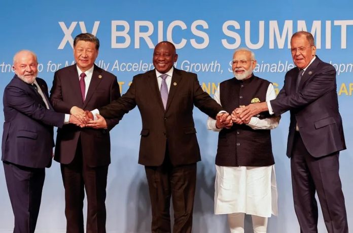
The week before the map’s publication, China’s President Xi Jinping and Indian Prime Minister Narendra Modi had met on the sidelines of the BRICS summit and pledged to settle their border dispute. The China-India relationship was set to get another boost at the upcoming G-20 Summit in India, although it now seems unclear that Xi will attend. China-Russia relationship also appeared strengthened after the BRICS summit, after members voted for a proposal, backed by both countries, to expand the group. It would also seem unwise for Xi to give his neighbors something to rally together against at the ASEAN meeting that begins September 5.
However, China’s map sends a message of strength and aggression that it has consistently been broadcasting to its neighbors—and its own people. China has been ramping up its military efforts, sending ships in protest each time that its neighbors show support for international law. Within the past year, Indonesia has ended years-long EEZ disputes with both Vietnam and Indonesia in accordance with UNCLOS boundaries. China has responded by stepping up patrols and incursions in the maritime zones it disputes with all three countries. These actions have been particularly acute in Vietnam, where China has entered gas blocks owned by Russian companies in Vietnam’s EEZ, and where the China Coast Guard attacked a Vietnamese fishing vessel with a water cannon on the day the map was released. China now clenches its map in the fist that it waves at UNCLOS and the countries who support it.


